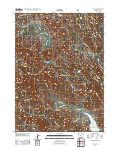
2011 Map of Cox Flat
USGS Topo · Published 2011About this map
Cox Flat and the surrounding timberlands of Lake County define this high-country landscape as it appeared in the early 21st century. The geography is heavily marked by industrial history, most notably the uranium mining legacy represented by the Lucky Lass Mine and the nearby White King Mine. These sites sit amidst a complex network of waterways, including Thomas Creek and Augur Creek, which flow through a terrain transitioned from resource extraction to recreation. Public access is concentrated around the Irishmans Campground and the Cottonwood Creek Trailhead, providing entry points for the many springs and small drainages that feed the Cottonwood Reservoir in the southern portion of the quadrangle. The map captures a moment of modern forest management, where a web of secondary routes and a prominent Logging RD service the various forks of Cottonwood Creek and Mesman Creek.
Find a feature on this map
21 named features on this map. Tap any name to fly to it.
Don’t see what you’re looking for? This feature index may not catch every label — zoom into the map to look around manually.
Map Details
Editions of this 2011 Cox Flat Map
This is the sole edition of this map. No revisions or reprints were ever made.
Other maps of this area

1955 · Klamath Falls
USGS Topo · 1:250,000

1958 · Klamath Falls
USGS Topo · 1:250,000

1964 · Drews Reservoir
USGS Topo · 1:24,000

1964 · Cox Flat
USGS Topo · 1:24,000

1964 · Lakeview NW
USGS Topo · 1:24,000

1964 · Coleman Point
USGS Topo · 1:24,000

1964 · Cougar Peak
USGS Topo · 1:24,000

1964 · Shoestring Butte
USGS Topo · 1:24,000

1964 · Drews Gap
USGS Topo · 1:24,000

1964 · Clover Flat
USGS Topo · 1:24,000