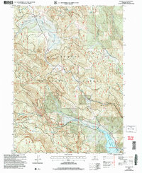
2004 Map of Cox Flat
USGS Topo · Published 2007About this map
The Fremont National Forest landscape shown here reflects the high-country activity of Lake County, where resource extraction and water management define the topography. Centered around Thomas Cox Flat Creek, this area includes several noteworthy mineral sites, such as the Lucky Lass Mine and White King Mine, as well as numerous scattered Prospects. The industrial presence is balanced by the infrastructure for outdoor recreation and ranching, evidenced by the Boat Ramp at the Lower Cottonwood Reservoir and the historic Garrett Place. Natural springs, including Hunter Spring and Bogas Spring, punctuate the drainages that feed into Cottonwood Reservoir. This 2004 revision by the Forest Service provides a clear view of the complex road and trail network, like the Cottonwood Trail, used for managing this timber and mineral-rich region.
Find a feature on this map
26 named features on this map. Tap any name to fly to it.
Don’t see what you’re looking for? This feature index may not catch every label — zoom into the map to look around manually.
Map Details
Editions of this 2004 Cox Flat Map
This is the sole edition of this map. No revisions or reprints were ever made.
Other maps of this area

1955 · Klamath Falls
USGS Topo · 1:250,000

1958 · Klamath Falls
USGS Topo · 1:250,000

1964 · Drews Reservoir
USGS Topo · 1:24,000

1964 · Cox Flat
USGS Topo · 1:24,000

1964 · Lakeview NW
USGS Topo · 1:24,000

1964 · Coleman Point
USGS Topo · 1:24,000

1964 · Cougar Peak
USGS Topo · 1:24,000

1964 · Shoestring Butte
USGS Topo · 1:24,000

1964 · Drews Gap
USGS Topo · 1:24,000

1964 · Clover Flat
USGS Topo · 1:24,000