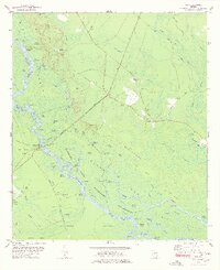
1978 Map of Cox
USGS Topo · Published 1978About this map
The Altamaha River carves a winding path through the McIntosh County wetlands, defining a landscape shaped by water and timber. This late 1970s survey captures the region where the Seaboard Coast Line railroad bisects the swamp, connecting the small settlement of Cox to the broader coastal corridor. The river is flanked by numerous oxbow lakes and named pockets such as Gamecock Lake, Belly Hole Lake, and Old Womans Pocket, reflecting generations of local fishing and navigation history.
Find a feature on this map
97 named features on this map. Tap any name to fly to it.
Don’t see what you’re looking for? This feature index may not catch every label — zoom into the map to look around manually.
Map Details
Editions of this 1978 Cox Map
2 editions found
Other maps of this area

1918 · Everett City
USGS Topo · 1:62,500

1920 · Sapelo River
USGS Topo · 1:62,500

1920 · Everett City
USGS Topo · 1:62,500

1921 · Darien
USGS Topo · 1:62,500

1943 · Ludowici
USGS Topo · 1:62,500

1943 · Sapelo River
USGS Topo · 1:62,500

1944 · Everett City
USGS Topo · 1:62,500

1945 · Sapelo River
USGS Topo · 1:62,500

1946 · Brunswick
USGS Topo · 1:250,000

1948 · Brunswick
USGS Topo · 1:250,000