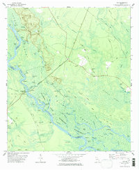
1978 Map of Cox
USGS Topo · Published 1978About this map
The Altamaha River winds through a dense network of backwaters and named oxbows in this coastal Georgia survey, marking the jurisdictional borders between McIntosh, Glynn, and Wayne counties. The landscape is dominated by the Altamaha Waterfowl Management Area and the vast Clayhole Swamp, where intricate waterways like Lewis Creek and Hornsby Creek carve through low-lying ridges. The Seaboard Coast Line railroad provides a straight diagonal corridor across this water-bound terrain, connecting the settlement at Cox with the river landing at Altamaha Park.
Find a feature on this map
83 named features on this map. Tap any name to fly to it.
Don’t see what you’re looking for? This feature index may not catch every label — zoom into the map to look around manually.
Map Details
Editions of this 1978 Cox Map
2 editions found
Other maps of this area

1918 · Everett City
USGS Topo · 1:62,500

1920 · Sapelo River
USGS Topo · 1:62,500

1920 · Everett City
USGS Topo · 1:62,500

1921 · Darien
USGS Topo · 1:62,500

1943 · Ludowici
USGS Topo · 1:62,500

1943 · Sapelo River
USGS Topo · 1:62,500

1944 · Everett City
USGS Topo · 1:62,500

1945 · Sapelo River
USGS Topo · 1:62,500

1946 · Brunswick
USGS Topo · 1:250,000

1948 · Brunswick
USGS Topo · 1:250,000