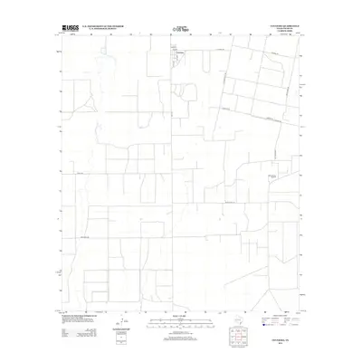
2012 Map of Coyanosa
USGS Topo · Published 2012About this map
Coyanosa serves as the primary hub in this arid section of Pecos County, characterized by a structured grid of agricultural and industrial access roads. The landscape reflects the region's reliance on underground resources, evidenced by the presence of the Athey Oil and Gas Field and infrastructure like Water Well Rd. Heavy industry and energy production are further highlighted by specialized routes such as Mobil Plant Rd, which connects the extraction areas to the broader transportation network of Fm-1776.
Find a feature on this map
15 named features on this map. Tap any name to fly to it.
Don’t see what you’re looking for? This feature index may not catch every label — zoom into the map to look around manually.
Map Details
Editions of this 2012 Coyanosa Map
This is the sole edition of this map. No revisions or reprints were ever made.
Other maps of this area

1931 · Barstow
USGS Topo · 1:125,000

1954 · Pecos
USGS Topo · 1:250,000

1957 · Pecos
USGS Topo · 1:250,000

1963 · Ligon Ranch
USGS Topo · 1:24,000

1963 · Rio Pecos Ranch
USGS Topo · 1:24,000
1973 · Coyanosa NW
USGS Topo · 1:24,000
1974 · Coyanosa
USGS Topo · 1:24,000
1974 · Coyanosa SW
USGS Topo · 1:24,000
1974 · Diamond Y Spring
USGS Topo · 1:24,000
1974 · Diamond Y Spring NW
USGS Topo · 1:24,000