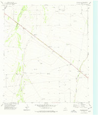
1974 Map of Coyanosa SW
USGS Topo · Published 1977About this map
Hackberry Draw and Coyanosa Draw carve through the arid West Texas landscape, defining the topography of this Pecos County region in the mid-1970s. The map illustrates a landscape shaped by both cattle ranching and resource extraction, anchored by Mendel Ranch and the locality of Mendel. The presence of several family-named water sources, such as Lawerance Windmill, Ligon Windmill, and Beard Windmill, underscores the necessity of groundwater management in this environment. Industrial infrastructure is visible through a network of Gas Wells, Drill Holes, and a significant Pipeline crossing the southern portion of the sheet. For those interested in the infrastructure of the era, the map also identifies a Gaging Sta near the draw and a Roadside Park along the highway, offering a clear record of 20th-century rural Texas land use.
Find a feature on this map
16 named features on this map. Tap any name to fly to it.
Don’t see what you’re looking for? This feature index may not catch every label — zoom into the map to look around manually.
Map Details
Editions of this 1974 Coyanosa SW Map
This is the sole edition of this map. No revisions or reprints were ever made.
Other maps of this area

1929 · Hovey
USGS Topo · 1:125,000

1931 · Barstow
USGS Topo · 1:125,000

1954 · Pecos
USGS Topo · 1:250,000

1954 · Fort Stockton
USGS Topo · 1:250,000

1957 · Pecos
USGS Topo · 1:250,000

1958 · Fort Stockton
USGS Topo · 1:250,000

1970 · Tucker Hill
USGS Topo · 1:24,000

1970 · Belding NW
USGS Topo · 1:24,000
1970 · Barstow 3 SE
USGS Topo · 1:24,000

1970 · Barstow 3 NE
USGS Topo · 1:24,000