
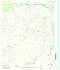
1963 Map of Ligon Ranch
USGS Topo · Published 1965About this map
The Pecos River carves the northern boundary of this West Texas landscape, where the borders of Ward, Reeves, and Pecos counties converge. During the early 1960s, this arid terrain was defined by the infrastructure of the West Waha Oil Field, characterized by a network of drill holes and unimproved roads. The presence of the Automotive Proving Ground in the southwest corner indicates the region's utility for wide-scale industrial testing, taking advantage of the expansive, open flats.
Find a feature on this map
17 named features on this map. Tap any name to fly to it.
Don’t see what you’re looking for? This feature index may not catch every label — zoom into the map to look around manually.
Map Details
Editions of this 1963 Ligon Ranch Map
2 editions found
Other maps of this area

1931 · Barstow
USGS Topo · 1:125,000

1954 · Pecos
USGS Topo · 1:250,000

1957 · Pecos
USGS Topo · 1:250,000

1963 · Old X Ranch
USGS Topo · 1:24,000

1963 · Quito Draw
USGS Topo · 1:24,000

1963 · China Lake NE
USGS Topo · 1:24,000

1963 · Rio Pecos Ranch
USGS Topo · 1:24,000

1963 · China Lake
USGS Topo · 1:24,000

1970 · Barstow 3 NE
USGS Topo · 1:24,000
1973 · Coyanosa NW
USGS Topo · 1:24,000