
1963 Map of Quito Draw
USGS Topo · Published 1965About this map
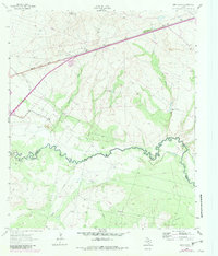
The Pecos River and its confluence with Toyah Creek anchor this mid-1960s study of the Ward Co Reeves Co boundary line. This arid landscape is defined by the logistics of water and resource extraction, visible in the network of the Lateral and Canal systems that cut through the terrain. A notable engineering project is the Texas and Pacific RR (Under Construction), which traverses the northern portion of the sheet near Hays Hill. The map documents a scattered industrial and agricultural footprint, from numerous Oil Wells and a central Quarry to specialized locations like the Barstow Water Tank and isolated outposts such as Barstow Well. The presence of the A W R R E Field and various named wells like Teague Well and Jones Well provides specific touchpoints for local historians and genealogists tracking family land use and early energy development in West Texas.
Find a feature on this map
23 named features on this map. Tap any name to fly to it.
Don’t see what you’re looking for? This feature index may not catch every label — zoom into the map to look around manually.
Map Details
Editions of this 1963 Quito Draw Map
2 editions found
Other maps of this area

1931 · Barstow
USGS Topo · 1:125,000

1954 · Pecos
USGS Topo · 1:250,000

1957 · Pecos
USGS Topo · 1:250,000

1961 · Soda Lake
USGS Topo · 1:24,000

1963 · Ligon Ranch
USGS Topo · 1:24,000

1963 · Old X Ranch
USGS Topo · 1:24,000

1963 · China Lake
USGS Topo · 1:24,000

1963 · Pecos East
USGS Topo · 1:24,000

1963 · Toyah Lake
USGS Topo · 1:24,000

1968 · Soda Lake SE
USGS Topo · 1:24,000