
1963 Map of China Lake
USGS Topo · Published 1965About this map
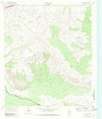
The Pecos River carves a path through this West Texas landscape, marking the boundary between Ward Co and Reeves Co. In the mid-1960s, the region was defined by a complex intersection of natural features and industrial infrastructure. Broad depressions like China Lake and Horseshoe Lake sit north of the river, while a network of pipelines, an aqueduct, and a canal demonstrate the intensive water and energy management required in this arid environment.
Find a feature on this map
14 named features on this map. Tap any name to fly to it.
Don’t see what you’re looking for? This feature index may not catch every label — zoom into the map to look around manually.
Map Details
Editions of this 1963 China Lake Map
2 editions found
Other maps of this area

1931 · Barstow
USGS Topo · 1:125,000

1954 · Pecos
USGS Topo · 1:250,000

1957 · Pecos
USGS Topo · 1:250,000

1963 · Ligon Ranch
USGS Topo · 1:24,000

1963 · Old X Ranch
USGS Topo · 1:24,000

1963 · Quito Draw
USGS Topo · 1:24,000

1963 · China Lake NE
USGS Topo · 1:24,000

1963 · Rio Pecos Ranch
USGS Topo · 1:24,000

1968 · Soda Lake SE
USGS Topo · 1:24,000

1969 · Pyote East
USGS Topo · 1:24,000