
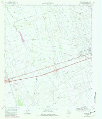
1969 Map of Pyote East
USGS Topo · Published 1971About this map
Industrial expansion and ranching heritage intersect in this late 1960s study of Ward County. The landscape is heavily defined by the petroleum industry, with extensive drilling and infrastructure spanning the South Sealy Oil Field, North Ward Estes Oil Field, and Wickett South Oil Field. A complex network of pipelines and access roads serves these fields, while the town of Wickett stands as a local hub complete with a refinery and water tanks. To the west, the village of Pyote sits along the dual tracks of the Texas and Pacific railroad, which parallels the main highway and its Roadside Park. Amidst this energy infrastructure, traditional land use persists at the Tie Ranch and Thorton Ranch, where essential water sources like the Half h Windmill and Recorder Windmill are vital markers on the arid terrain near Monument Draw.
Find a feature on this map
24 named features on this map. Tap any name to fly to it.
Don’t see what you’re looking for? This feature index may not catch every label — zoom into the map to look around manually.
Map Details
Editions of this 1969 Pyote East Map
2 editions found
Other maps of this area

1931 · Barstow
USGS Topo · 1:125,000

1954 · Pecos
USGS Topo · 1:250,000

1957 · Pecos
USGS Topo · 1:250,000

1963 · China Lake NE
USGS Topo · 1:24,000

1963 · China Lake
USGS Topo · 1:24,000

1968 · Wink South
USGS Topo · 1:24,000

1968 · China Ranch
USGS Topo · 1:24,000

1969 · Pyote NE
USGS Topo · 1:24,000

1969 · Monahans
USGS Topo · 1:24,000

1969 · 7 L Ranch
USGS Topo · 1:24,000