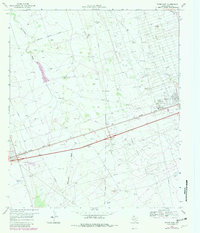
1969 Map of Pyote East
USGS Topo · Published 1981About this map
Industrial development and oil extraction define this Permian Basin landscape, where the Missouri Pacific railroad cuts a straight line through the desert terrain. The settlements of Pyote and Wickett serve as anchors along this rail corridor, surrounded by the extensive infrastructure of the Estes North Oil Field, South Sealy Oil Field, and Wickett South Oil Field. This network of pipelines, drill holes, and pumping stations reveals a period of intense energy production, supported by a system of gravel pits and a large aqueduct feeding the local operations.
Find a feature on this map
22 named features on this map. Tap any name to fly to it.
Don’t see what you’re looking for? This feature index may not catch every label — zoom into the map to look around manually.
Map Details
Editions of this 1969 Pyote East Map
2 editions found
Other maps of this area

1931 · Barstow
USGS Topo · 1:125,000

1954 · Pecos
USGS Topo · 1:250,000

1957 · Pecos
USGS Topo · 1:250,000

1963 · China Lake NE
USGS Topo · 1:24,000

1963 · China Lake
USGS Topo · 1:24,000

1968 · Wink South
USGS Topo · 1:24,000

1968 · China Ranch
USGS Topo · 1:24,000

1969 · Pyote NE
USGS Topo · 1:24,000

1969 · Pyote East
USGS Topo · 1:24,000

1969 · Monahans
USGS Topo · 1:24,000