
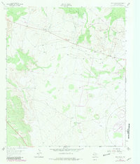
1963 Map of Old X Ranch
USGS Topo · Published 1965About this map
The Worsham Ranch and Old X Ranch anchor this West Texas landscape, illustrating the scale of ranching operations in Reeves County during the early 1960s. The map reveals an intricate network of resource extraction and industrial testing, most notably seen in the southeastern corner at the Automotive Proving Ground. This specialized facility suggests a transition in land use from traditional cattle ranging toward industrial and technological experimentation.
Find a feature on this map
15 named features on this map. Tap any name to fly to it.
Don’t see what you’re looking for? This feature index may not catch every label — zoom into the map to look around manually.
Map Details
Editions of this 1963 Old X Ranch Map
2 editions found
Other maps of this area

1931 · Barstow
USGS Topo · 1:125,000

1954 · Pecos
USGS Topo · 1:250,000

1957 · Pecos
USGS Topo · 1:250,000

1963 · Ligon Ranch
USGS Topo · 1:24,000

1963 · Quito Draw
USGS Topo · 1:24,000

1963 · China Lake
USGS Topo · 1:24,000

1963 · Pecos East
USGS Topo · 1:24,000

1963 · Toyah Lake
USGS Topo · 1:24,000

1970 · Barstow 3 NE
USGS Topo · 1:24,000
1970 · Barstow 3 NW
USGS Topo · 1:24,000