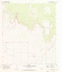
1970 Map of Barstow 3 NW
USGS Topo · Published 1973About this map
Barrilla Draw winds through this arid expanse of Reeves County, defining the local drainage patterns across a landscape marked by industrial activity and isolated agricultural footprints. In the early 1970s, the area's economy is visibly tied to resource extraction and land management, evidenced by several Gravel Pits and Oil Wells scattered throughout the quadrangle. The presence of Davidson Farm near the southern boundary suggests the persistence of ranching or farming in a territory dominated by intermittent watercourses and technical infrastructure like the WT station. This survey captures a moment of transition where traditional land use and the growing petroleum and mineral extraction industries shared the West Texas terrain.
Find a feature on this map
5 named features on this map. Tap any name to fly to it.
Don’t see what you’re looking for? This feature index may not catch every label — zoom into the map to look around manually.
Map Details
Editions of this 1970 Barstow 3 NW Map
2 editions found
Other maps of this area

1921 · Toyah
USGS Topo · 1:125,000

1931 · Barstow
USGS Topo · 1:125,000

1954 · Pecos
USGS Topo · 1:250,000

1955 · Saragosa
USGS Topo · 1:62,500

1957 · Pecos
USGS Topo · 1:250,000

1963 · Old X Ranch
USGS Topo · 1:24,000

1963 · Toyah Lake
USGS Topo · 1:24,000
1970 · Barstow 3 SW
USGS Topo · 1:24,000
1970 · Barstow 3 SE
USGS Topo · 1:24,000

1970 · Barstow 3 NE
USGS Topo · 1:24,000