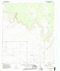
1970 Map of Barrilla Draw North
USGS Topo · Published 1995About this map
Davidson Farm sits in the flat expanse of West Texas, reflecting the agricultural and industrial activity of the region during the early 1970s. The landscape is defined by the intermittent watercourse of Barrilla Draw, which cuts through the terrain where scattered Wells provide a critical resource for ranching and farming. Subsurface interests are evident through the presence of an Oil Well, highlighting the energy extraction that characterizes the economy of Reeves County. Surveyed following 1969 aerial photography, the map also identifies multiple Gravel Pit locations, indicating local material sourcing for road infrastructure and construction in this arid environment.
Find a feature on this map
6 named features on this map. Tap any name to fly to it.
Don’t see what you’re looking for? This feature index may not catch every label — zoom into the map to look around manually.
Map Details
Editions of this 1970 Barrilla Draw North Map
2 editions found
Other maps of this area

1921 · Toyah
USGS Topo · 1:125,000

1931 · Barstow
USGS Topo · 1:125,000

1954 · Pecos
USGS Topo · 1:250,000

1955 · Saragosa
USGS Topo · 1:62,500

1957 · Pecos
USGS Topo · 1:250,000

1963 · Old X Ranch
USGS Topo · 1:24,000

1963 · Toyah Lake
USGS Topo · 1:24,000
1970 · Barstow 3 SW
USGS Topo · 1:24,000
1970 · Barstow 3 SE
USGS Topo · 1:24,000

1970 · Barstow 3 NE
USGS Topo · 1:24,000