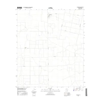
2016 Map of Coyanosa
USGS Topo · Published 2016About this map
Coyanosa serves as the primary hub of activity in this arid Pecos County landscape, where the town's grid is defined by streets like Battie St and Frank St. The surrounding geography is heavily influenced by the industrial and agricultural needs of the Permian Basin, evidenced by the extensive network of service roads and specialized corridors. The intermittent path of Coyanosa Draw meanders through the western portion of the quadrangle, providing a natural contrast to the rigid geometry of the local infrastructure.
Find a feature on this map
14 named features on this map. Tap any name to fly to it.
Don’t see what you’re looking for? This feature index may not catch every label — zoom into the map to look around manually.
Map Details
Editions of this 2016 Coyanosa Map
This is the sole edition of this map. No revisions or reprints were ever made.
Other maps of this area

1931 · Barstow
USGS Topo · 1:125,000

1954 · Pecos
USGS Topo · 1:250,000

1957 · Pecos
USGS Topo · 1:250,000

1963 · Ligon Ranch
USGS Topo · 1:24,000

1963 · Rio Pecos Ranch
USGS Topo · 1:24,000
1973 · Coyanosa NW
USGS Topo · 1:24,000
1974 · Coyanosa
USGS Topo · 1:24,000
1974 · Coyanosa SW
USGS Topo · 1:24,000
1974 · Diamond Y Spring
USGS Topo · 1:24,000
1974 · Diamond Y Spring NW
USGS Topo · 1:24,000