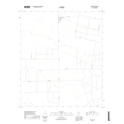
2019 Map of Coyanosa
USGS Topo · Published 2019About this map
Coyanosa serves as the primary hub in this arid reach of Pecos County, centered at the intersection of Ranch Rd 1776 and Weatherby Rd. The landscape is defined by the broad drainage of Coyanosa Draw, which meanders through the western portion of the quadrangle. This 2019 survey reflects the industrial and residential patterns of the Permian Basin, where utility-oriented thoroughfares like Mobil Plant Rd and Water Well Field Rd intersect with local streets such as Battle St and Bettie St. The town site itself includes a Po, marking its role as a persistent community center for the surrounding ranching and oil-producing lands. Further north, specialized routes like Trailer House Rd and Stephan Ln suggest the clustered living arrangements often associated with the region's resource extraction economy.
Find a feature on this map
15 named features on this map. Tap any name to fly to it.
Don’t see what you’re looking for? This feature index may not catch every label — zoom into the map to look around manually.
Map Details
Editions of this 2019 Coyanosa Map
This is the sole edition of this map. No revisions or reprints were ever made.
Other maps of this area

1931 · Barstow
USGS Topo · 1:125,000

1954 · Pecos
USGS Topo · 1:250,000

1957 · Pecos
USGS Topo · 1:250,000

1963 · Ligon Ranch
USGS Topo · 1:24,000

1963 · Rio Pecos Ranch
USGS Topo · 1:24,000
1973 · Coyanosa NW
USGS Topo · 1:24,000
1974 · Coyanosa
USGS Topo · 1:24,000
1974 · Coyanosa SW
USGS Topo · 1:24,000
1974 · Diamond Y Spring
USGS Topo · 1:24,000
1974 · Diamond Y Spring NW
USGS Topo · 1:24,000