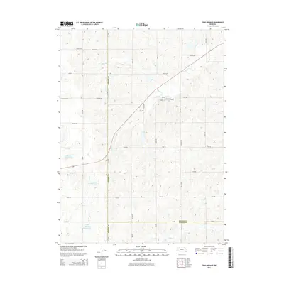
2014 Map of Crab Orchard
USGS Topo · Published 2014About this map
Crab Orchard serves as the central hub of this agricultural landscape at the tri-county junction where Johnson, Gage, and Pawnee counties meet. The village is defined by its simple grid of streets, including Main St and Lombard St, and the nearby Crab Orchard Cem southwest of the town center. The surrounding terrain is a network of drainage systems, dominated by the winding paths of Yankee Cr, Turkey Cr, and Laflins Br. A notable modern addition to this rural geography is the series of water management features, including Mud Cr Reservoir 2-D, Mud Cr Reservoir 2-F, and Mud Cr Reservoir 2-H, which dot the western half of the quadrangle. These reservoirs, alongside the various forks of Mud Cr, illustrate the region's managed approach to soil and water conservation in the early 21st century.
Find a feature on this map
35 named features on this map. Tap any name to fly to it.
Don’t see what you’re looking for? This feature index may not catch every label — zoom into the map to look around manually.
Map Details
Editions of this 2014 Crab Orchard Map
This is the sole edition of this map. No revisions or reprints were ever made.
Other maps of this area

1955 · Lincoln
USGS Topo · 1:250,000

1957 · Lincoln
USGS Topo · 1:250,000

1958 · Lincoln
USGS Topo · 1:250,000

1965 · Adams
USGS Topo · 1:24,000

1965 · Crab Orchard
USGS Topo · 1:24,000

1965 · Burchard
USGS Topo · 1:24,000

1965 · Sterling
USGS Topo · 1:24,000

1965 · Lewiston
USGS Topo · 1:24,000
1965 · Vesta
USGS Topo · 1:24,000
1965 · St. Mary
USGS Topo · 1:24,000