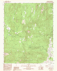
1987 Map of Crag Peak
USGS Topo · Published 1994About this map
Pacific Crest National Scenic Trail hikers in the 1980s crossed a landscape defined by the intersection of several major protected areas, including the Sequoia National Forest, Inyo National Forest, and the South Sierra Wilderness. This High Sierra region is characterized by high-altitude meadows and dramatic peaks. Large drainage systems like Fish Creek and Jackass Creek feed into the South Fork Kern River, which winds through the eastern portion of the map near the Kennedy Meadows area.
Find a feature on this map
31 named features on this map. Tap any name to fly to it.
Don’t see what you’re looking for? This feature index may not catch every label — zoom into the map to look around manually.
Map Details
Editions of this 1987 Crag Peak Map
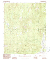
2 editions found
Other maps of this area

1905 · Olancha
USGS Topo · 1:125,000

1906 · Kernville
USGS Topo · 1:125,000

1907 · Olancha
USGS Topo · 1:125,000

1908 · Kernville
USGS Topo · 1:125,000

1948 · Bakersfield
USGS Topo · 1:250,000

1948 · Fresno
USGS Topo · 1:250,000

1955 · Bakersfield
USGS Topo · 1:250,000

1955 · Fresno
USGS Topo · 1:250,000

1956 · Bakersfield
USGS Topo · 1:250,000

1956 · Fresno
USGS Topo · 1:250,000