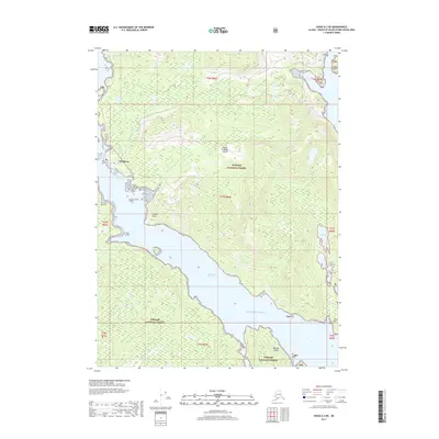
2017 Map of Craig A-3 NE
USGS Topo · Published 2017About this map
Hydaburg serves as the primary coastal settlement on this portion of Prince of Wales Island, situated where the Hydaburg River meets the protected waters of Sukkuan Narrows. The town’s compact grid, including Main Street, contrasts with the expansive, undeveloped reaches of the Tongass National Forest that cover much of the surrounding terrain. This landscape is defined by its intricate shoreline, where the Sukkuan Strait separates the main island from its neighbors, and landmarks like Saltery Point and Eek Point navigate the transition toward the open Pacific Ocean. Farther north and east, the map traces isolated water bodies such as Eek Lake and the sheltered indentation of Deer Bay, illustrating the reliance on maritime access and narrow coastal corridors for movement throughout the region.
Find a feature on this map
22 named features on this map. Tap any name to fly to it.
Don’t see what you’re looking for? This feature index may not catch every label — zoom into the map to look around manually.
Map Details
Editions of this 2017 Craig A-3 NE Map
This is the sole edition of this map. No revisions or reprints were ever made.
Other maps of this area

1948 · Craig A-3
USGS Topo · 1:63,360

1948 · Craig A-2
USGS Topo · 1:63,360

1949 · Craig B-2
USGS Topo · 1:63,360

1949 · Craig B-3
USGS Topo · 1:63,360

1951 · Craig B-2
USGS Topo · 1:63,360

1951 · Craig B-3
USGS Topo · 1:63,360

1951 · Craig A-2
USGS Topo · 1:63,360

1951 · Craig A-3
USGS Topo · 1:63,360

1957 · Craig
USGS Topo · 1:250,000
1996 · Craig A-2
USGS Topo · 1:63,360