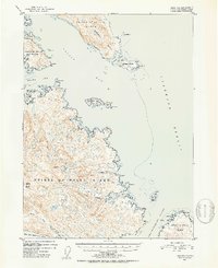
1950 Map of Craig B-1
USGS Topo · Published 1953About this map
Prince of Wales Island serves as the focal point of this coastal survey, defined by the intricate waterways of Southeast Alaska. The settlement of Kasaan is located on the northern shore of Kasaan Bay, while the smaller outpost of Grindall sits near the eastern tip of Grindall Point. The landscape is dominated by high relief, featuring prominent summits like Clover Mtn and Nipple Butte, which overlook a network of freshwater bodies including Clover Lake and Monie Lake.
Find a feature on this map
48 named features on this map. Tap any name to fly to it.
Don’t see what you’re looking for? This feature index may not catch every label — zoom into the map to look around manually.
Map Details
Editions of this 1950 Craig B-1 Map
2 editions found
Other maps of this area

1948 · Ketchikan A-6
USGS Topo · 1:63,360

1948 · Craig A-1
USGS Topo · 1:63,360

1948 · Craig A-2
USGS Topo · 1:63,360

1949 · Craig C-2
USGS Topo · 1:63,360

1949 · Craig B-2
USGS Topo · 1:63,360

1949 · Ketchikan C-6
USGS Topo · 1:63,360

1949 · Craig B-1
USGS Topo · 1:63,360

1950 · Craig B-1
USGS Topo · 1:63,360

1950 · Craig C-1
USGS Topo · 1:63,360

1951 · Craig B-2
USGS Topo · 1:63,360