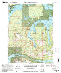
1997 Map of Craig B-2
USGS Topo · Published 2000About this map
Prince of Wales Island anchors this late-twentieth-century study of the Alexander Archipelago, where the complex interplay of marine inlets and timbered ridges is meticulously documented. The settlement of Hollis sits near the head of Twelvemile Arm, serving as a gateway to the Maybeso Experimental Forest. This region of the Tongass National Forest illustrates a maritime economy built on forestry and natural resource management, evidenced by the presence of a Logging Camp on Skowl Arm and the industrial footprint of the Khayyam Mine.
Find a feature on this map
48 named features on this map. Tap any name to fly to it.
Don’t see what you’re looking for? This feature index may not catch every label — zoom into the map to look around manually.
Map Details
Editions of this 1997 Craig B-2 Map
This is the sole edition of this map. No revisions or reprints were ever made.
Other maps of this area

1948 · Craig A-1
USGS Topo · 1:63,360

1948 · Craig A-3
USGS Topo · 1:63,360

1948 · Craig A-2
USGS Topo · 1:63,360

1949 · Craig C-2
USGS Topo · 1:63,360

1949 · Craig B-2
USGS Topo · 1:63,360

1949 · Craig B-3
USGS Topo · 1:63,360

1949 · Craig C-3
USGS Topo · 1:63,360

1949 · Craig B-1
USGS Topo · 1:63,360

1950 · Craig B-1
USGS Topo · 1:63,360

1950 · Craig C-1
USGS Topo · 1:63,360