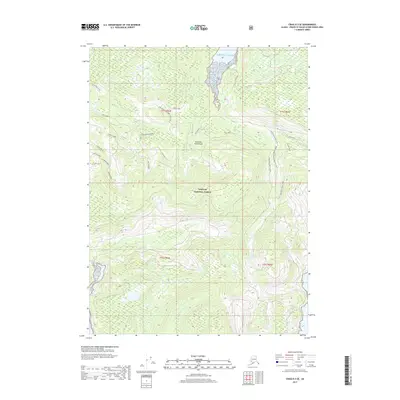
2017 Map of Craig B-3 SE
USGS Topo · Published 2017About this map
The Alexander Archipelago landscape is defined by the dense forest of the Tongass National Forest, where steep ridges and deep drainages flow toward the Pacific Ocean. This 2017 survey shows a network of logging and service roads, including Polk Road and various numbered routes like 2100110 Road, winding through the interior to reach the water. Significant drainages such as the Hudaburg River and Dog Salmon dominate the hydrology of the area. Notable terrain features like the Twentylemile Creek E Ridge and Twentylemile Creek W Slope provide a clear view of the elevation changes typical of Prince of Wales Island. The presence of smaller creeks like Lower Cable Creek and Perry Cr indicates the intricate watershed system that supports this coastal environment.
Find a feature on this map
29 named features on this map. Tap any name to fly to it.
Don’t see what you’re looking for? This feature index may not catch every label — zoom into the map to look around manually.
Map Details
Editions of this 2017 Craig B-3 SE Map
This is the sole edition of this map. No revisions or reprints were ever made.
Other maps of this area

1948 · Craig A-3
USGS Topo · 1:63,360

1948 · Craig A-2
USGS Topo · 1:63,360

1949 · Craig B-2
USGS Topo · 1:63,360

1949 · Craig B-3
USGS Topo · 1:63,360

1951 · Craig B-2
USGS Topo · 1:63,360

1951 · Craig B-3
USGS Topo · 1:63,360

1951 · Craig A-2
USGS Topo · 1:63,360

1951 · Craig A-3
USGS Topo · 1:63,360

1957 · Craig
USGS Topo · 1:250,000
1996 · Craig A-2
USGS Topo · 1:63,360