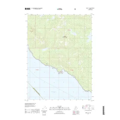
2017 Map of Craig C-1 SE
USGS Topo · Published 2017About this map
Tongass National Forest dominates this coastal landscape on the southeastern edge of Prince of Wales Island. The terrain is defined by steep forested ridges and isolated freshwater bodies such as Rainbow Lake and Smugglers Lake. Along the shoreline, geographic markers like Niblack Point and the adjacent Niblack Hollow provide critical reference points for the coastal navigation of the Pacific Ocean. This survey documents a wilderness area where the boundary between the Ketchikan Gateway Borough and the Prince of Wales-Hyder Census Area meets the sea. The drainage patterns of Smugglers Cr illustrate the complex hydrology of the Alexander Archipelago, showing how inland runoff feeds the intricate shoreline of this maritime environment.
Find a feature on this map
12 named features on this map. Tap any name to fly to it.
Don’t see what you’re looking for? This feature index may not catch every label — zoom into the map to look around manually.
Map Details
Editions of this 2017 Craig C-1 SE Map
This is the sole edition of this map. No revisions or reprints were ever made.
Other maps of this area

1949 · Ketchikan C-6
USGS Topo · 1:63,360

1949 · Craig B-1
USGS Topo · 1:63,360

1950 · Craig B-1
USGS Topo · 1:63,360

1950 · Craig C-1
USGS Topo · 1:63,360

1951 · Craig C-1
USGS Topo · 1:63,360

1952 · Ketchikan
USGS Topo · 1:250,000

1952 · Ketchikan C-6
USGS Topo · 1:63,360

1953 · Ketchikan B-6
USGS Topo · 1:63,360

1954 · Ketchikan B-6
USGS Topo · 1:63,360

1955 · Ketchikan
USGS Topo · 1:250,000