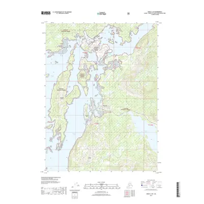
2017 Map of Craig C-4 SE
USGS Topo · Published 2017About this map
Craig and Klawock anchor this coastal survey of Prince of Wales Island, where the maritime landscape of the Tongass National Forest meets the intricate waterways of Southeast Alaska. The map documents the vital infrastructure connecting these communities, from the residential corridors of Bayview Boulevard and Anchorage Street to the regional hub at Klawock Airport. The geography is defined by a dense network of islands and passages, including Wadleigh and Peratrovich Island, which shield the waters of Klawock Inlet.
Find a feature on this map
25 named features on this map. Tap any name to fly to it.
Don’t see what you’re looking for? This feature index may not catch every label — zoom into the map to look around manually.
Map Details
Editions of this 2017 Craig C-4 SE Map
This is the sole edition of this map. No revisions or reprints were ever made.
Other maps of this area

1949 · Craig B-3
USGS Topo · 1:63,360

1949 · Craig C-3
USGS Topo · 1:63,360

1949 · Craig C-4
USGS Topo · 1:63,360

1949 · Craig B-4
USGS Topo · 1:63,360

1951 · Craig C-3
USGS Topo · 1:63,360

1951 · Craig B-4
USGS Topo · 1:63,360

1951 · Craig C-4
USGS Topo · 1:63,360

1951 · Craig B-3
USGS Topo · 1:63,360

1957 · Craig
USGS Topo · 1:250,000
1994 · Craig C-3
USGS Topo · 1:63,360