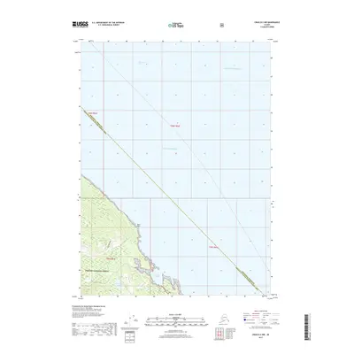
2017 Map of Craig D-2 NW
USGS Topo · Published 2017About this map
Tongass National Forest dominates the southern landscape of this coastal survey, where the rugged shoreline of Prince of Wales Island meets the waters of Clarence Strait. The topography is defined by the drainage systems of Ratz Cr, which flows from the interior highlands toward the sheltered waters of Ratz Harbor. This area is characterized by a network of timber-management routes, most notably the 1025500 Road, which provides access through the densely forested terrain. Freshwater features like Trumpeter Lake and Ratz Lake are situated just inland from the coast, marking the transition from the maritime environment of the Gulf of Alaska and Pacific Ocean to the mountainous wilderness of the Alexander Archipelago. The map also delineates the administrative boundary between the Wrangell Borough and the neighboring census area.
Find a feature on this map
15 named features on this map. Tap any name to fly to it.
Don’t see what you’re looking for? This feature index may not catch every label — zoom into the map to look around manually.
Map Details
Editions of this 2017 Craig D-2 NW Map
This is the sole edition of this map. No revisions or reprints were ever made.
Other maps of this area

1948 · Petersburg A-2
USGS Topo · 1:63,360

1949 · Craig D-3
USGS Topo · 1:63,360

1949 · Craig D-2
USGS Topo · 1:63,360

1949 · Petersburg A-3
USGS Topo · 1:63,360

1950 · Craig D-3
USGS Topo · 1:63,360

1951 · Craig D-2
USGS Topo · 1:63,360

1952 · Petersburg
USGS Topo · 1:250,000

1953 · Petersburg A-3
USGS Topo · 1:63,360

1953 · Petersburg A-2
USGS Topo · 1:63,360

1957 · Craig
USGS Topo · 1:250,000