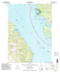
1994 Map of Craig D-2
USGS Topo · Published 1998About this map
Prince of Wales Island and the rugged shores of Etolin Island face one another across the deep waters of the Clarence Strait. This coastal survey documents the intricate network of coves and anchorages essential for maritime navigation within the Tongass National Forest, showing a landscape defined by protected harbors and small islands. Notable maritime landmarks include the Lighthouse Reserve near Ratz Harbor and the Cabin Ruins situated near Narrow Pt.
Find a feature on this map
38 named features on this map. Tap any name to fly to it.
Don’t see what you’re looking for? This feature index may not catch every label — zoom into the map to look around manually.
Map Details
Editions of this 1994 Craig D-2 Map
This is the sole edition of this map. No revisions or reprints were ever made.
Other maps of this area

1948 · Petersburg A-1
USGS Topo · 1:63,360

1948 · Petersburg A-2
USGS Topo · 1:63,360

1949 · Craig D-3
USGS Topo · 1:63,360

1949 · Craig C-2
USGS Topo · 1:63,360

1949 · Craig D-2
USGS Topo · 1:63,360

1949 · Petersburg A-3
USGS Topo · 1:63,360

1949 · Craig C-3
USGS Topo · 1:63,360

1949 · Craig D-1
USGS Topo · 1:63,360

1950 · Craig D-3
USGS Topo · 1:63,360

1950 · Craig C-1
USGS Topo · 1:63,360