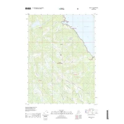
2017 Map of Craig D-2 SW
USGS Topo · Published 2017About this map
Prince of Wales Island within the Tongass National Forest is defined by its deep coastal inlets and managed forest lands. The coastline is marked by Little Ratz Harbor, while the interior terrain is carved by a dense network of drainages including Ratz Creek, Gravelly Creek, and Fiddler Creek. This 2017 survey reflects the modern management of the Alexander Archipelago, showing an extensive system of timber and access roads such as Thorne Bay 3018271 Rd and 3000270 Road. These routes navigate prominent geographic markers like Deer Creek Mid-Vally and Bottom of the Hill, illustrating the complex relationship between the steep maritime topography and the infrastructure required to access these remote reaches of Southeast Alaska.
Find a feature on this map
32 named features on this map. Tap any name to fly to it.
Don’t see what you’re looking for? This feature index may not catch every label — zoom into the map to look around manually.
Map Details
Editions of this 2017 Craig D-2 SW Map
This is the sole edition of this map. No revisions or reprints were ever made.
Other maps of this area

1949 · Craig D-3
USGS Topo · 1:63,360

1949 · Craig C-2
USGS Topo · 1:63,360

1949 · Craig D-2
USGS Topo · 1:63,360

1949 · Craig C-3
USGS Topo · 1:63,360

1950 · Craig D-3
USGS Topo · 1:63,360

1951 · Craig C-3
USGS Topo · 1:63,360

1951 · Craig D-2
USGS Topo · 1:63,360

1951 · Craig C-2
USGS Topo · 1:63,360

1957 · Craig
USGS Topo · 1:250,000
1994 · Craig D-3
USGS Topo · 1:63,360