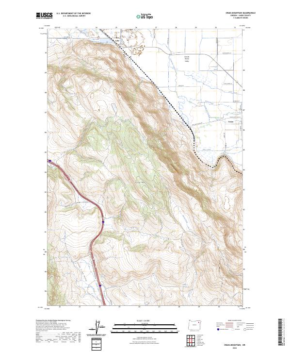
2024 Map of Craig Mountain
USGS Topo · Published 2024About this map
Grande Ronde Valley agricultural lands meet the rising timbered slopes of Craig Mtn in this contemporary topographic record of Union County. The settlement of Union anchors the eastern edge of the map, situated where Catherine Creek and Pyles Creek descend into the valley floor. To the northwest, the distinctive Hot Lake area features its namesake Hot Lake Reservoir, a site with a long history of geothermal prominence. The landscape is defined by its water management and transit corridors, from the winding path of Ladd Canyon to the intricate irrigation network of Grout Ditch and Scott Ditch in the Clover Creek Valley. These features reveal how the natural geography of springs like Kaylor Spring and Thompson Spring has been harnessed to support the valley's ranching and farming operations.
Find a feature on this map
38 named features on this map. Tap any name to fly to it.
Don’t see what you’re looking for? This feature index may not catch every label — zoom into the map to look around manually.
Map Details
Editions of this 2024 Craig Mountain Map
This is the sole edition of this map. No revisions or reprints were ever made.
Other maps of this area

1906 · Telocaset
USGS Topo · 1:125,000

1953 · Pendleton
USGS Topo · 1:250,000

1955 · Grangeville
USGS Topo · 1:250,000

1956 · Pendleton
USGS Topo · 1:250,000

1959 · Grangeville
USGS Topo · 1:250,000

1963 · La Grande SE
USGS Topo · 1:24,000

1965 · Conley
USGS Topo · 1:24,000
1965 · Glass Hill
USGS Topo · 1:24,000
1965 · Tucker Flat
USGS Topo · 1:24,000

1965 · Union
USGS Topo · 1:24,000