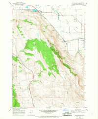
1966 Map of Craig Mountain
USGS Topo · Published 1967About this map
Craig Mountain towers over the southeastern edge of the Grande Ronde Valley, creating a sharp topographical divide between the agricultural lowlands and the elevated timbered slopes. In the 1960s, the lower valley floor shows a complex transportation network where the Union Pacific Railroad meets the Oregon of Union Railroad at Union Junction, serving the nearby community of Union. To the northwest, the Ladd Marsh Game Management Area borders the steep ascent into Ladd Canyon, highlighting the importance of wildlife conservation alongside the region's agricultural use. The presence of Hot Lake and numerous springs indicates the thermal activity and water sources that supported early settlement and industrial efforts, such as the Gravel Pit near the mountain's base. Water management is further evidenced by Davis Dam and a Reservoir that harness the flow of Catherine Creek and Pyles Creek for the valley below.
Find a feature on this map
25 named features on this map. Tap any name to fly to it.
Don’t see what you’re looking for? This feature index may not catch every label — zoom into the map to look around manually.
Map Details
Editions of this 1966 Craig Mountain Map
This is the sole edition of this map. No revisions or reprints were ever made.
Other maps of this area

1906 · Telocaset
USGS Topo · 1:125,000

1953 · Pendleton
USGS Topo · 1:250,000

1955 · Grangeville
USGS Topo · 1:250,000

1956 · Pendleton
USGS Topo · 1:250,000

1959 · Grangeville
USGS Topo · 1:250,000

1963 · La Grande SE
USGS Topo · 1:24,000

1965 · Conley
USGS Topo · 1:24,000
1965 · Glass Hill
USGS Topo · 1:24,000
1965 · Tucker Flat
USGS Topo · 1:24,000

1965 · Union
USGS Topo · 1:24,000