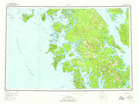
1957 Map of Craig
USGS Topo · Published 1959About this map
Prince of Wales Island and its surrounding archipelago define this mid-century survey of the Alexander Archipelago. The map captures a landscape of maritime industry and early mining, highlighting the central hub of Craig and the settlement at Klawak. While established towns like Hydaburg and Hollis appear active, the map records the transition of earlier outposts including Deweyville and Tuxekan.
Find a feature on this map
131 named features on this map. Tap any name to fly to it.
Don’t see what you’re looking for? This feature index may not catch every label — zoom into the map to look around manually.
Map Details
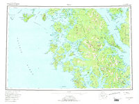
Editions of this 1957 Craig Map
3 editions found

Other maps of this area

1948 · Craig A-4
USGS Topo · 1:63,360

1948 · Petersburg A-6
USGS Topo · 1:63,360

1948 · Petersburg A-1
USGS Topo · 1:63,360

1948 · Dixon Entrance D-5
USGS Topo · 1:63,360

1948 · Petersburg A-2
USGS Topo · 1:63,360

1948 · Port Alexander A-1
USGS Topo · 1:63,360

1948 · Craig B-5
USGS Topo · 1:63,360

1948 · Craig A-5
USGS Topo · 1:63,360

1948 · Dixon Entrance D-2
USGS Topo · 1:63,360

1948 · Prince Rupert D-6
USGS Topo · 1:63,360