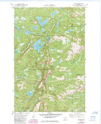
1981 Map of Cramer
USGS Topo · Published 1985About this map
The Sawtooth Mountains rise above the Lake County interior in this early 1980s survey, dominated by the dense timber of the Superior National Forest and Finland State Forest. The small settlement of Cramer serves as a central point in a landscape defined by its glacial hydrology, featuring dozens of named water bodies like Ninemile Lake, Bonanza Lake, and Thunderbird Lake. Historical industrial activity is etched into the terrain via an Old Railroad Grade and several extractive sites, including a Quarry and various Gravel Pit locations. High-relief topography is further protected within the George H Crosby Manitou State Park, where the Manitou River cuts through the forest. The map captures a moment of transition where the old logging rail infrastructure remained visible alongside emerging recreational developments like the Campground and Boat Ramp at Ninemile Lake.
Find a feature on this map
36 named features on this map. Tap any name to fly to it.
Don’t see what you’re looking for? This feature index may not catch every label — zoom into the map to look around manually.
Map Details
Editions of this 1981 Cramer Map
2 editions found
Other maps of this area

1954 · Two Harbors
USGS Topo · 1:250,000

1955 · Schroeder
USGS Topo · 1:24,000

1955 · Tofte
USGS Topo · 1:62,500

1955 · Cramer
USGS Topo · 1:62,500

1956 · Little Marais
USGS Topo · 1:24,000

1956 · Finland
USGS Topo · 1:24,000

1956 · Finland
USGS Topo · 1:62,500

1957 · Two Harbors
USGS Topo · 1:250,000

1958 · Two Harbors
USGS Topo · 1:250,000

1964 · Two Harbors
USGS Topo · 1:250,000