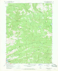
1967 Map of Crandall Canyon
USGS Topo · Published 1969About this map
Rockport State Park and the impounded waters of Rockport Lake anchor the southwestern corner of this late-1960s survey. The landscape is defined by the high, ridged terrain of the Elkhorn Divide and Big Piney Mountain, where numerous canyons like Crandall Canyon and Cottonwood Canyon drain toward the Weber River. The map captures a moment when the area was largely utilized for recreation and resource management, evidenced by the scattered corrals and a Gaging Station monitoring river flow.
Find a feature on this map
31 named features on this map. Tap any name to fly to it.
Don’t see what you’re looking for? This feature index may not catch every label — zoom into the map to look around manually.
Map Details
Editions of this 1967 Crandall Canyon Map
2 editions found
Other maps of this area

1885 · Salt Lake
USGS Topo · 1:250,000

1900 · Coalville
USGS Topo · 1:125,000

1903 · Coalville
USGS Topo · 1:125,000

1954 · Salt Lake City
USGS Topo · 1:250,000

1955 · Park City East
USGS Topo · 1:24,000

1958 · Salt Lake City
USGS Topo · 1:250,000

1960 · Salt Lake City
USGS Topo · 1:250,000
1967 · Turner Hollow
USGS Topo · 1:24,000

1967 · Kamas
USGS Topo · 1:24,000
1967 · Wanship
USGS Topo · 1:24,000