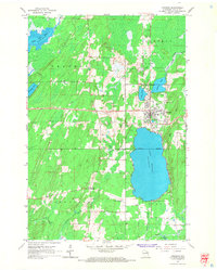
1965 Map of Crandon
USGS Topo · Published 1966About this map
The city of Crandon serves as the hub of this Forest County landscape, situated at the northern end of the expansive Lake Metonga. This mid-1960s survey captures the area's transition away from its heavy logging roots, shown by the extensive network of an Old Railroad Grade and Railroad Grade that once hauled timber through the townships of Crandon, Lincoln, and Nashville. The northern reaches are dominated by water and wetlands, including Little Rice Lake on the Wolf River and Peshtigo Lake, which sits adjacent to the Lakeside Cemetery and the County Fairground.
Find a feature on this map
31 named features on this map. Tap any name to fly to it.
Don’t see what you’re looking for? This feature index may not catch every label — zoom into the map to look around manually.
Map Details
Editions of this 1965 Crandon Map
2 editions found
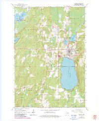
Other maps of this area

1939 · Crandon
USGS Topo · 1:48,000

1940 · Monico
USGS Topo · 1:48,000

1941 · Crandon
USGS Topo · 1:48,000

1942 · Elcho
USGS Topo · 1:48,000

1942 · Pearson
USGS Topo · 1:48,000

1947 · Crandon
USGS Topo · 1:48,000

1950 · Monico
USGS Topo · 1:48,000

1950 · Elcho
USGS Topo · 1:48,000

1950 · Lily
USGS Topo · 1:48,000

1954 · Iron Mountain
USGS Topo · 1:250,000