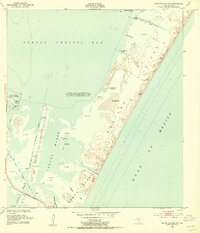
1951 Map of Crane Islands NW
USGS Topo · Published 1955About this map
Mustang Island and the northern tip of Padre Island dominate this coastal survey, separated by the narrow inlet of Corpus Christi Pass. The map captures a critical transition in the Texas coastal landscape, documenting the established Corpus Christi Naval Air Station and the newly developed Laguna Madre Causeway connecting the mainland to the barrier islands. Within the Laguna Madre, the Crane Islands sit amidst a complex network of sand and mud flats and the busy Intracoastal Waterway. To the north, Corpus Christi Bay meets the island shore at Shamrock Cove, where an active oil field and numerous spoil banks indicate the industrial and maritime activity of the early 1950s. The detail includes numerous daybeacons and lights used for navigating the shifting coastal channels like Packery Channel and Newport Pass.
Find a feature on this map
18 named features on this map. Tap any name to fly to it.
Don’t see what you’re looking for? This feature index may not catch every label — zoom into the map to look around manually.
Map Details
Editions of this 1951 Crane Islands NW Map
2 editions found
Other maps of this area

1925 · Aransas Pass
USGS Topo · 1:62,500

1925 · Oso Creek
USGS Topo · 1:62,500

1925 · Corpus Christi
USGS Topo · 1:62,500

1950 · Corpus Christi
USGS Topo · 1:250,000

1951 · Portland
USGS Topo · 1:24,000

1951 · Corpus Christi
USGS Topo · 1:62,500

1951 · Crane Islands NW
USGS Topo · 1:24,000

1951 · Oso Creek NE
USGS Topo · 1:24,000

1951 · Crane Islands SW
USGS Topo · 1:24,000

1951 · Oso Creek
USGS Topo · 1:62,500