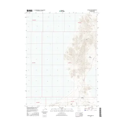
2017 Map of Crater Island
USGS Topo · Published 2017About this map
Crater Island and the northern reaches of the Silver Island Mountains define this landscape within the Great Salt Lake Desert. This 2017 survey details a stark environment where high-elevation landmasses rise abruptly from the surrounding flats, connected only by the unpaved Crater Island Rd and Silver Island Rd. The map illustrates the path through Donner Reed Pass, a location of significant interest for those tracing the historical overland routes across the salt desert. While the terrain is dominated by the steep contours of Silver Island, the inclusion of the Public Land Survey System grid provides a precise framework for locating specific sections and township boundaries like t4n r17w and t5n r17w.
Find a feature on this map
12 named features on this map. Tap any name to fly to it.
Don’t see what you’re looking for? This feature index may not catch every label — zoom into the map to look around manually.
Map Details
Editions of this 2017 Crater Island Map
This is the sole edition of this map. No revisions or reprints were ever made.
Other maps of this area

1953 · Tooele
USGS Topo · 1:250,000

1954 · Brigham City
USGS Topo · 1:250,000

1955 · Tooele
USGS Topo · 1:250,000

1958 · Brigham City
USGS Topo · 1:250,000

1962 · Brigham City
USGS Topo · 1:250,000
1967 · Crater Island SW
USGS Topo · 1:24,000

1967 · Lemay Island
USGS Topo · 1:24,000
1967 · Crater Island NW
USGS Topo · 1:24,000

1970 · Crater Island
USGS Topo · 1:24,000

1971 · Silver Island Pass
USGS Topo · 1:24,000