1967 Map of Crater Island SW
USGS Topo · Published 1972About this map
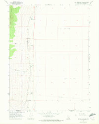
The Donner-Reed Trail cuts across the southern reach of this landscape, marking a historic route through the unforgiving Great Salt Lake Desert. This 1967 survey captures the intersection of the Pilot Range and the expansive Alkali Or Mud flats of the basin. Reliable water sources were critical in this arid environment, and the map documents several essential points including Donner Spring, South Patterson Spring, and a localized Well. The terrain is characterized by a stark transition from the steep elevations of the western mountains down to the level desert floor, where Sand Dunes and seasonal watercourses like Bettridge Creek disappear into the mud. Modern transit is represented only by a primitive Jeep Trail, emphasizing the isolated and primitive nature of this borderland between Box Elder and Tooele counties.
Find a feature on this map
15 named features on this map. Tap any name to fly to it.
Don’t see what you’re looking for? This feature index may not catch every label — zoom into the map to look around manually.
Map Details
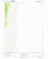
Editions of this 1967 Crater Island SW Map
2 editions found
Other maps of this area

1953 · Tooele
USGS Topo · 1:250,000

1954 · Brigham City
USGS Topo · 1:250,000

1955 · Tooele
USGS Topo · 1:250,000

1955 · Wells
USGS Topo · 1:250,000

1955 · Elko
USGS Topo · 1:250,000

1958 · Wells
USGS Topo · 1:250,000

1958 · Elko
USGS Topo · 1:250,000

1958 · Brigham City
USGS Topo · 1:250,000

1961 · Wells
USGS Topo · 1:250,000

1962 · Elko
USGS Topo · 1:250,000