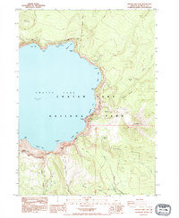
1985 Map of Crater Lake East
USGS Topo · Published 1995About this map
Crater Lake dominates this 1985 survey, its deep waters framed by the precipitous walls of the caldera in eastern Klamath County. Along the shoreline, specific geomorphic and historic features are documented, including the Phantom Ship formation in Danger Bay and the sheer face of Dutton Cliff. The map traces the eastern rim's complex topography, from the heights of Mt Scott—crowned by a Lookout House—down to the Anderson Bluffs. Notable for local history and land management is the Old Indian Reservation Boundary cutting across the northern and southern sectors. Recreational and scientific development is evident through the presence of a Gaging Station and Boat Landing at Cleetwood Cove, alongside various viewpoints and picnic areas that serve visitors to Crater Lake National Park.
Find a feature on this map
56 named features on this map. Tap any name to fly to it.
Don’t see what you’re looking for? This feature index may not catch every label — zoom into the map to look around manually.
Map Details
Editions of this 1985 Crater Lake East Map
2 editions found
Other maps of this area

1889 · Klamath
USGS Topo · 1:250,000

1891 · Ashland
USGS Topo · 1:250,000

1893 · Ashland
USGS Topo · 1:250,000

1894 · Klamath
USGS Topo · 1:250,000

1897 · Ashland
USGS Topo · 1:250,000

1917 · Diamond Lake
USGS Topo · 1:125,000

1935 · Chemult
USGS Topo · 1:96,000

1941 · Chemult
USGS Topo · 1:125,000

1955 · Crescent
USGS Topo · 1:250,000

1955 · Klamath Falls
USGS Topo · 1:250,000