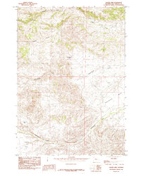
1985 Map of Crater Sink
USGS Topo · Published 1985About this map
Crater Sink defines the southwestern corner of this high-elevation Wyoming landscape, a region marked by deep drainage patterns and distinct topographic benches. The watershed is dominated by the system of Wagonhound Creek, which cuts through the center of the quadrangle supported by Wagonhound Spring and framed by the elevated Wagonhound Bench.
Find a feature on this map
7 named features on this map. Tap any name to fly to it.
Don’t see what you’re looking for? This feature index may not catch every label — zoom into the map to look around manually.
Map Details
Editions of this 1985 Crater Sink Map
This is the sole edition of this map. No revisions or reprints were ever made.
Other maps of this area

1913 · Grass Creek Basin
USGS Topo · 1:62,500

1915 · Grass Creek Basin
USGS Topo · 1:62,500

1955 · Thermopolis
USGS Topo · 1:250,000

1956 · Twentyone Creek
USGS Topo · 1:24,000

1956 · Adam Weiss Peak
USGS Topo · 1:24,000

1958 · Thermopolis
USGS Topo · 1:250,000

1962 · Thermopolis
USGS Topo · 1:250,000

1965 · Arapahoe Ranch
USGS Topo · 1:24,000
1965 · Embar
USGS Topo · 1:24,000
1965 · Anchor Reservoir
USGS Topo · 1:24,000