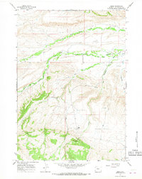
1965 Map of Embar
USGS Topo · Published 1968About this map
The Wind River Indian Reservation Boundary cuts through this landscape of high plains and drainages in Hot Springs County. The settlement of Embar sits near the confluence of the North Fork Owl Creek and South Fork Owl Creek, serving as a focal point for the surrounding ranching and early petroleum activity. To the south, Brooks Ranch occupies a position near Dry Rock Spring Creek, while the expansive Riley Flat dominates the southeastern quadrant.
Find a feature on this map
15 named features on this map. Tap any name to fly to it.
Don’t see what you’re looking for? This feature index may not catch every label — zoom into the map to look around manually.
Map Details
Editions of this 1965 Embar Map
This is the sole edition of this map. No revisions or reprints were ever made.
Other maps of this area

1913 · Grass Creek Basin
USGS Topo · 1:62,500

1915 · Grass Creek Basin
USGS Topo · 1:62,500

1952 · Kates Basin
USGS Topo · 1:24,000

1952 · Sheep Ridge
USGS Topo · 1:24,000

1952 · Bargee
USGS Topo · 1:24,000

1955 · Thermopolis
USGS Topo · 1:250,000

1956 · Twentyone Creek
USGS Topo · 1:24,000

1958 · Thermopolis
USGS Topo · 1:250,000

1962 · Thermopolis
USGS Topo · 1:250,000

1965 · Arapahoe Ranch
USGS Topo · 1:24,000