
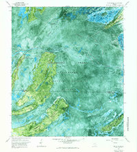
1966 Map of Cravens Island
USGS Topo · Published 1968About this map
Hopkins serves as a lone outpost on the edge of the Okefenokee Swamp in this experimental photomap. The landscape is a mosaic of dense vegetation and open water, characterized by numerous islands and hammocks that break the swamp's surface. Notable landmarks include Cravens Island and Hog Island, while the presence of a Dismantled Logging Tram and Mc Leods Mill points to the area's history of timber extraction. These industrial traces are interwoven with natural features like Suwannee Creek and Piney Woods Lake.
Find a feature on this map
32 named features on this map. Tap any name to fly to it.
Don’t see what you’re looking for? This feature index may not catch every label — zoom into the map to look around manually.
Map Details
Editions of this 1966 Cravens Island Map
This is the sole edition of this map. No revisions or reprints were ever made.
Other maps of this area

1953 · Waycross
USGS Topo · 1:250,000

1954 · Valdosta
USGS Topo · 1:250,000

1958 · Valdosta
USGS Topo · 1:250,000

1958 · Waycross
USGS Topo · 1:250,000

1959 · Valdosta
USGS Topo · 1:250,000

1965 · Dinner Pond
USGS Topo · 1:24,000
1966 · Billys Island
USGS Topo · 1:24,000

1966 · The Pocket
USGS Topo · 1:24,000

1967 · Waycross SE
USGS Topo · 1:24,000

1967 · Spooner
USGS Topo · 1:24,000