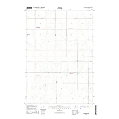
2015 Map of Cresbard SE
USGS Topo · Published 2015About this map
Devoe Cem sits along the western edge of this Faulk County landscape, a quiet landmark within the expansive agricultural grid of the eastern Dakotas. The terrain is defined by the winding paths of South Fork Snake Creek and Perry Cr, which break the geometric precision of the section lines. This 2015 survey reflects the enduring rural character of the region, where the Public Land Survey System has dictated the placement of nearly every road, including 157th St and 371st Ave. The drainage patterns of the S Fork Snake Cr system suggest a prairie landscape of seasonal wetlands and subtle depressions, typical of the glacial till plains that characterize this portion of South Dakota.
Find a feature on this map
22 named features on this map. Tap any name to fly to it.
Don’t see what you’re looking for? This feature index may not catch every label — zoom into the map to look around manually.
Map Details
Editions of this 2015 Cresbard SE Map
This is the sole edition of this map. No revisions or reprints were ever made.
Other maps of this area

1899 · Northville
USGS Topo · 1:125,000

1899 · Redfield
USGS Topo · 1:125,000

1953 · Huron
USGS Topo · 1:250,000

1954 · Aberdeen
USGS Topo · 1:250,000

1954 · Huron
USGS Topo · 1:250,000

1956 · Aberdeen
USGS Topo · 1:250,000

1966 · Cresbard SE
USGS Topo · 1:24,000
1966 · Miranda
USGS Topo · 1:24,000
1966 · Northville SW
USGS Topo · 1:24,000
1966 · Chelsea
USGS Topo · 1:24,000