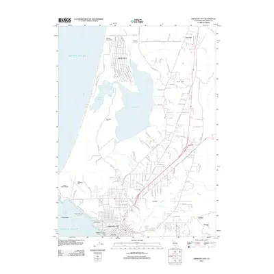
2012 Map of Crescent City
USGS Topo · Published 2012About this map
Crescent City serves as the focal point of this Del Norte coast survey, sitting at the junction of maritime and inland routes. The landscape is defined by the significant coastal lagoons of Lake Earl and Lake Talawa, which are separated from the Pacific Ocean by a narrow strip of land containing Kellogg Road Beach and the planned grid of Pacific Shores. The map documents the local aviation infrastructure at Jack McNamara Field and the surrounding agricultural and rural residential patterns in Fort Dick and Kings Valley. Genealogists and local historians can locate specific landmarks such as the Jonathan Cem and the reef near Brother Jonathan, a name tied to one of the most significant maritime disasters of the Pacific Northwest. From the rocky outcrop of Point Saint George to the heights of Howland Hill, the map illustrates a region where the rugged coastline meets the low-lying valleys of Elk Cr.
Find a feature on this map
106 named features on this map. Tap any name to fly to it.
Don’t see what you’re looking for? This feature index may not catch every label — zoom into the map to look around manually.
Map Details
Editions of this 2012 Crescent City Map
This is the sole edition of this map. No revisions or reprints were ever made.
Other maps of this area

1929 · Crescent City
USGS Topo · 1:125,000

1945 · Point St. George
USGS Topo · 1:62,500

1945 · Requa
USGS Topo · 1:62,500

1949 · Eureka
USGS Topo · 1:250,000
1952 · Klamath
USGS Topo · 1:62,500

1952 · Crescent City
USGS Topo · 1:62,500
1956 · Sister Rocks
USGS Topo · 1:24,000

1956 · Crescent City
USGS Topo · 1:24,000

1956 · Smith River
USGS Topo · 1:24,000

1958 · Eureka
USGS Topo · 1:250,000