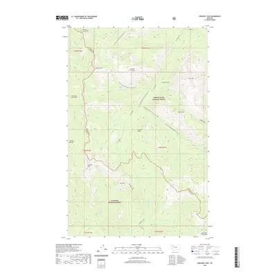
2020 Map of Crescent Cliff
USGS Topo · Published 2020About this map
The Continental Divide National Scenic Trail winds through this high-altitude landscape where the Sawtooth Range meets the Lewis and Clark Range. This 2020 survey documents a transition in wilderness management, straddling the boundary between the Lewis & Clark National Forest and the Flathead National Forest. The map is characterized by a series of prominent peaks, including Running Crane Mtn, Bullshoe Mtn, and Running Owl Mtn, which define the drainage basins for numerous creeks. Significant watercourses such as Lodgepole Creek, Pool Cr, and Whistler Cr flow from these heights, illustrating the complex hydrology of the continental divide. The presence of the Pondera and Flathead county line bisecting the terrain highlights how political boundaries often follow the highest ridges of these mountain chains.
Find a feature on this map
37 named features on this map. Tap any name to fly to it.
Don’t see what you’re looking for? This feature index may not catch every label — zoom into the map to look around manually.
Map Details
Editions of this 2020 Crescent Cliff Map
This is the sole edition of this map. No revisions or reprints were ever made.
Other maps of this area

1913 · Marias Pass
USGS Topo · 1:125,000

1958 · Red Plume Mountain
USGS Topo · 1:24,000

1958 · Gable Peaks
USGS Topo · 1:24,000

1958 · Capitol Mountain
USGS Topo · 1:24,000

1958 · Crescent Cliff
USGS Topo · 1:24,000

1960 · Cut Bank
USGS Topo · 1:250,000

1963 · Cut Bank
USGS Topo · 1:250,000

1964 · Cut Bank
USGS Topo · 1:250,000

1968 · Half Dome Crag
USGS Topo · 1:24,000
1968 · Gooseberry Park
USGS Topo · 1:24,000