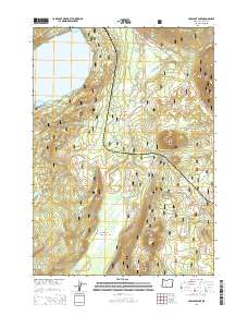
2014 Map of Crescent Lake
USGS Topo · Published 2014About this map
Crescent Lake dominates the northwest corner of this high-elevation landscape within the Deschutes National Forest. Located along the eastern edge of the Cascade Range, the terrain is defined by volcanic features, most notably the prominent volcanic peaks of Odell Butte, Little Odell Butte, Beales Butte, and Chinquapin Butte. These landmarks serve as anchor points for a complex network of forestry access routes, including the Lava Odell Rd and the Willamette Hwy which cuts across the northeastern sector. The hydrology of the area is equally intricate, with Big Marsh Creek and Crescent Creek draining the timbered basins. Smaller water sources like Little Odell Spring and Oldenburg Lake are visible, tucked into the higher elevations. This modern survey illustrates the current management of public lands, where traditional forest development roads like Nat For Dev Rd 5814 provide access to the remote backcountry of Klamath County.
Find a feature on this map
35 named features on this map. Tap any name to fly to it.
Don’t see what you’re looking for? This feature index may not catch every label — zoom into the map to look around manually.
Map Details
Editions of this 2014 Crescent Lake Map
This is the sole edition of this map. No revisions or reprints were ever made.
Other maps of this area

1917 · Diamond Lake
USGS Topo · 1:125,000

1925 · Waldo Lake
USGS Topo · 1:125,000

1930 · Maiden Peak
USGS Topo · 1:125,000

1934 · Maiden Peak
USGS Topo · 1:125,000

1935 · Chemult
USGS Topo · 1:96,000

1941 · Chemult
USGS Topo · 1:125,000

1955 · Crescent
USGS Topo · 1:250,000

1956 · Waldo Lake
USGS Topo · 1:62,500

1956 · Summit Lake
USGS Topo · 1:62,500

1957 · Crescent
USGS Topo · 1:250,000