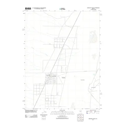
2012 Map of Crescent Valley
USGS Topo · Published 2012About this map
Crescent Valley serves as the focal point of this high-desert landscape in Eureka County, displaying a grid of residential and local streets during the early twenty-first century. The community is anchored by the Crescent Valley Rural Branch Post Office and supported by the Crescent Valley Landing Strip just to the east. The arid geography is defined by seasonal watercourses like Fire Creek and geothermal features including the Crescent Valley Hot Springs near Hot Springs Point. A network of thoroughfares such as McDaniel Ave and Hillbilly Ln weave through the valley floor, connecting the core settlement to the surrounding basin. This survey documents the intersection of rural Nevada living and the area's distinct natural hydrology, where name-branded roads like Dean-Dann-Spa reflect the local infrastructure surrounding the geothermal resources.
Find a feature on this map
35 named features on this map. Tap any name to fly to it.
Don’t see what you’re looking for? This feature index may not catch every label — zoom into the map to look around manually.
Map Details
Editions of this 2012 Crescent Valley Map
This is the sole edition of this map. No revisions or reprints were ever made.
Other maps of this area

1949 · Crescent Valley
USGS Topo · 1:62,500

1950 · Crescent Valley
USGS Topo · 1:62,500

1955 · Winnemucca
USGS Topo · 1:250,000

1957 · Frenchie Creek
USGS Topo · 1:62,500

1957 · Dunphy
USGS Topo · 1:62,500

1957 · Beowawe
USGS Topo · 1:62,500

1958 · Winnemucca
USGS Topo · 1:250,000

1962 · Winnemucca
USGS Topo · 1:250,000
1985 · Hand-Me-Down Creek
USGS Topo · 1:24,000

1985 · Mud Spring Gulch
USGS Topo · 1:24,000