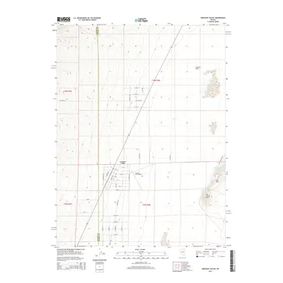
2015 Map of Crescent Valley
USGS Topo · Published 2015About this map
Crescent Valley occupies a wide basin on this 2015 survey, serving as a primary settlement hub along the boundary of Lander Co and Eureka Co. The town's grid is clearly defined by residential streets such as 1st St and Boulder Ln, supporting a localized infrastructure centered around the Crescent Valley Airport. The surrounding landscape is defined by geothermal and hydrologic activity, notably the Crescent Valley Hot Springs and Hot Springs Point to the southeast. These features sit at the base of the Dry Hills, where the transition from the flat valley floor to the desert uplands is marked by drainage from Fire Cr. The map captures a modern rural Nevada community where wide-open ranching or mining access roads like Fire Creek Rd and Cold Spring Point Rd connect isolated homesteads to the central township.
Find a feature on this map
28 named features on this map. Tap any name to fly to it.
Don’t see what you’re looking for? This feature index may not catch every label — zoom into the map to look around manually.
Map Details
Editions of this 2015 Crescent Valley Map
This is the sole edition of this map. No revisions or reprints were ever made.
Other maps of this area

1949 · Crescent Valley
USGS Topo · 1:62,500

1950 · Crescent Valley
USGS Topo · 1:62,500

1955 · Winnemucca
USGS Topo · 1:250,000

1957 · Frenchie Creek
USGS Topo · 1:62,500

1957 · Dunphy
USGS Topo · 1:62,500

1957 · Beowawe
USGS Topo · 1:62,500

1958 · Winnemucca
USGS Topo · 1:250,000

1962 · Winnemucca
USGS Topo · 1:250,000
1985 · Hand-Me-Down Creek
USGS Topo · 1:24,000

1985 · Mud Spring Gulch
USGS Topo · 1:24,000