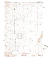
1985 Map of Crescent Valley
USGS Topo · Published 1986About this map
Crescent Valley unfolds across this high-desert basin in the 1980s, revealing a landscape defined by industrial exploration and thermal activity. The settlement of Crescent Valley itself serves as a focal point, supported by a nearby Trailer Park and a prominent Landing Strip, suggesting the area's role as a base for regional mining and resource management. Numerous labels for Prospect and Mine pepper the terrain, particularly near the Dry Hills and Hot Springs Point.
Find a feature on this map
18 named features on this map. Tap any name to fly to it.
Don’t see what you’re looking for? This feature index may not catch every label — zoom into the map to look around manually.
Map Details
Editions of this 1985 Crescent Valley Map
This is the sole edition of this map. No revisions or reprints were ever made.
Other maps of this area

1949 · Crescent Valley
USGS Topo · 1:62,500

1950 · Crescent Valley
USGS Topo · 1:62,500

1955 · Winnemucca
USGS Topo · 1:250,000

1957 · Frenchie Creek
USGS Topo · 1:62,500

1957 · Dunphy
USGS Topo · 1:62,500

1957 · Beowawe
USGS Topo · 1:62,500

1958 · Winnemucca
USGS Topo · 1:250,000

1962 · Winnemucca
USGS Topo · 1:250,000
1985 · Hand-Me-Down Creek
USGS Topo · 1:24,000

1985 · Mud Spring Gulch
USGS Topo · 1:24,000