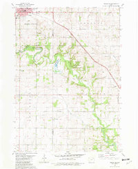
1981 Map of Cresco SE
USGS Topo · Published 1982About this map
Cresco anchors the northwest corner of this Northeast Iowa landscape, serving as a hub of civic life with its cluster of educational and religious institutions including Crestwood High Sch and the Notre Dame Sch PO. The surrounding countryside across the Howard and Winneshiek county line is defined by the winding course of the Turkey River, which is flanked by the Cardinal Marsh State Wildlife Area and Turkey River Access State Wildlife Area. This drainage network, supplemented by Otter Creek and Walnut Creek, reflects a region shaped by both agricultural utility and conservation efforts.
Find a feature on this map
32 named features on this map. Tap any name to fly to it.
Don’t see what you’re looking for? This feature index may not catch every label — zoom into the map to look around manually.
Map Details
Editions of this 1981 Cresco SE Map
This is the sole edition of this map. No revisions or reprints were ever made.
Other maps of this area

1906 · Decorah
USGS Topo · 1:125,000

1954 · Mason City
USGS Topo · 1:250,000

1957 · Mason City
USGS Topo · 1:250,000

1958 · Mason City
USGS Topo · 1:250,000

1958 · La Crosse
USGS Topo · 1:250,000

1961 · La Crosse
USGS Topo · 1:250,000

1965 · La Crosse
USGS Topo · 1:250,000

1975 · Decorah 2 NW
USGS Topo · 1:24,000

1975 · Decorah 3 NW
USGS Topo · 1:24,000

1975 · Decorah 2 SW
USGS Topo · 1:24,000