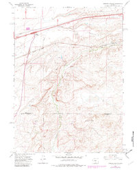
1966 Map of Creston Junction
USGS Topo · Published 1982About this map
Creston Junction marks the convergence of modern and historical transportation routes in this high desert landscape, where the legacy of the Union Pacific railroad and early highways dictates the settlement pattern. Moving east from the junction, the map reveals a series of small, isolated points of interest such as the Cherokee rail stop and the settlement of Fillmore, which sit nestled against the northern slopes of Cherokee Hill. The industrial footprint of the region is evident through features like Cherokee Mine No 1 and various gravel pits, highlighting the area's reliance on mineral extraction and infrastructure support.
Find a feature on this map
18 named features on this map. Tap any name to fly to it.
Don’t see what you’re looking for? This feature index may not catch every label — zoom into the map to look around manually.
Map Details
Editions of this 1966 Creston Junction Map
2 editions found
Other maps of this area

1954 · Rawlins
USGS Topo · 1:250,000

1958 · Rawlins
USGS Topo · 1:250,000

1962 · Rawlins
USGS Topo · 1:250,000

1966 · Jawbone Ranch
USGS Topo · 1:24,000

1966 · Creston Junction
USGS Topo · 1:24,000

1966 · Seaverson Reservoir
USGS Topo · 1:24,000

1966 · Riner
USGS Topo · 1:24,000

1966 · Creston
USGS Topo · 1:24,000

1966 · High Point
USGS Topo · 1:24,000

1966 · Fillmore Ranch
USGS Topo · 1:24,000