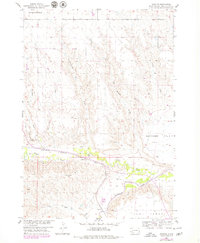
1954 Map of Creston
USGS Topo · Published 1979About this map
Creston sits at the intersection of rail and river in this mid-century western South Dakota landscape. The Chicago Milwaukee St Paul and Pacific railroad runs parallel to Rapid Creek, which winds its way toward a confluence with the Cheyenne River in the southeast. The terrain is defined by its deep drainage patterns and named plateaus, transitioning from the broad expanse of Holcomb Flat and Kube Table to the carved-out paths of Dipping Vat Draw and Swinehart Draw.
Find a feature on this map
18 named features on this map. Tap any name to fly to it.
Don’t see what you’re looking for? This feature index may not catch every label — zoom into the map to look around manually.
Map Details
Editions of this 1954 Creston Map
2 editions found
Other maps of this area

1953 · New Underwood
USGS Topo · 1:24,000

1953 · Folsom
USGS Topo · 1:24,000

1953 · Caputa NE
USGS Topo · 1:24,000

1953 · Rapid City
USGS Topo · 1:250,000

1954 · Scenic
USGS Topo · 1:24,000

1954 · Owanka
USGS Topo · 1:24,000

1954 · Creston
USGS Topo · 1:24,000

1954 · Scenic SW
USGS Topo · 1:24,000

1954 · Brennan Flat
USGS Topo · 1:24,000

1955 · Hot Springs
USGS Topo · 1:250,000